
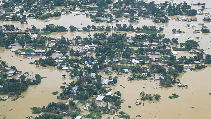
Flood Model showing Inundated Areas in Tarlac Due to Rain-Induced Habagat
Municipal- Region
- Region III (Central Luzon)
- Province
- Tarlac
- Municipality
- Pura
- Barangay
- —
- Coverage
- Aug 26, 2026 — Aug 31, 2026
Monitor flood extent, drought, and tropical cyclone impacts on Philippine agriculture with satellite-derived hazard layers and historical storm chronologies.
Latest flood extent layers derived from Sentinel-1 Synthetic Aperture Radar
| Map record | Title and description | Coverage | Flooded area | Source files | Uploaded | Action |
|---|---|---|---|---|---|---|
|
SNG_FLD_00053 SR25_CL_Zambales_083126 |
Sentinel-1 SAR-Based Flood Extent Map of Zambales Province, Central Luzon: Agricultural and Built-up Impact Assessment of Enhanced Habagat This map delineates surface water flooding across Central Luzon (Region III) using Sentinel-1 Synthetic Aperture Radar (SAR) imagery captur… |
Provincial
Region III (Central Luzon) Zambales |
1377.161 ha |
image Raster available description XML/PGW available |
Aug 31, 2026 9:13 PM |
visibility View |
|
SNG_FLD_00052 SR25_CL_Bataan_083126 |
Sentinel-1 SAR-Based Flood Extent Map of in Bataan Province, Central Luzon: Agricultural and Built-up Impact Assessment of Enhanced Habagat This map delineates surface water flooding across Central Luzon (Region III) using Sentinel-1 Synthetic Aperture Radar (SAR) imagery captur… |
Provincial
Region III (Central Luzon) Bataan |
414.606 ha |
image Raster available description XML/PGW available |
Aug 31, 2026 9:12 PM |
visibility View |
|
SNG_FLD_00051 SR25_CL_NuevaEcija_083126 |
Sentinel-1 SAR-Based Flood Extent Map of Nueva Ecija Province, Central Luzon: Agricultural and Built-up Impact Assessment of Enhanced Habagat This map delineates surface water flooding across Central Luzon (Region III) using Sentinel-1 Synthetic Aperture Radar (SAR) imagery captur… |
Provincial
Region III (Central Luzon) Nueva Ecija |
11109.179 ha |
image Raster available description XML/PGW available |
Aug 31, 2026 9:11 PM |
visibility View |
|
SNG_FLD_00050 SR25_CL_Pampanga_083126 |
Sentinel-1 SAR-Based Flood Extent Map of Pampanga Province, Central Luzon: Agricultural and Built-up Impact Assessment of Enhanced Habagat This map delineates surface water flooding across Central Luzon (Region III) using Sentinel-1 Synthetic Aperture Radar (SAR) imagery captur… |
Provincial
Region III (Central Luzon) Pampanga |
17882.653 ha |
image Raster available description XML/PGW available |
Aug 31, 2026 9:11 PM |
visibility View |
|
SNG_FLD_00049 SR25_CL_Aurora_083126 |
Sentinel-1 SAR-Based Flood Extent Map of Aurora Province, Central Luzon: Agricultural and Built-up Impact Assessment of Enhanced Habagat This map delineates surface water flooding across Central Luzon (Region III) using Sentinel-1 Synthetic Aperture Radar (SAR) imagery captur… |
Provincial
Region III (Central Luzon) Aurora |
456.948 ha |
image Raster available description XML/PGW available |
Aug 31, 2026 9:10 PM |
visibility View |
|
SNG_FLD_00048 SR25_CL_Bulacan_083126 |
Sentinel-1 SAR-Based Flood Extent Map of Bulacan Province, Central Luzon: Agricultural and Built-up Impact Assessment of Enhanced Habagat This map delineates surface water flooding across Central Luzon (Region III) using Sentinel-1 Synthetic Aperture Radar (SAR) imagery captur… |
Provincial
Region III (Central Luzon) Bulacan |
6101.64 ha |
image Raster available description XML/PGW available |
Aug 31, 2026 9:09 PM |
visibility View |
|
SNG_FLD_00047 SR25_CL_Tarlac_083126 |
Sentinel-1 SAR-Based Flood Extent Map of Tarlac Province, Central Luzon: Agricultural and Built-up Area Impact Assessment of Enhanced Habagat This map delineates surface water flooding across Central Luzon (Region III) using Sentinel-1 Synthetic Aperture Radar (SAR) imagery captur… |
Regional
Region III (Central Luzon) Tarlac |
7596.086 ha |
image Raster available description XML/PGW available |
Aug 31, 2026 9:07 PM |
visibility View |
|
SNG_FLD_00046 SR25_R2_Quirino_081226 |
Satellite-Based Flood Mapping in Quirino, Cagayan Valley: Agricultural Impact Assessment of TC Maymay and Habagat Maps showing the effects of TC Maymay and Enhanced Habagat in Certain Areas in Cagayan Valley. Note: May show swelling channels as Floods. |
Provincial
Region II (Cagayan Valley) Quirino |
347.13 ha |
image Raster available description XML/PGW available |
Aug 20, 2026 4:59 PM |
visibility View |
|
SNG_FLD_00045 SR25_R2_NuevaViscaya_081226 |
Satellite-Based Flood Mapping in Nueva Viscaya, Cagayan Valley: Agricultural Impact Assessment of TC Maymay and Habagat Maps showing the effects of TC Maymay and Enhanced Habagat in Certain Areas in Cagayan Valley. Note: May show swelling channels as Floods. |
Provincial
Region II (Cagayan Valley) Nueva Vizcaya |
1024.92 ha |
image Raster available description XML/PGW available |
Aug 20, 2026 4:55 PM |
visibility View |
|
SNG_FLD_00044 SR25_R2_Isabela_081226 |
Satellite-Based Flood Mapping in Isabela, Cagayan Valley: Agricultural Impact Assessment of TC Maymay and Habagat Maps showing the effects of TC Maymay and Enhanced Habagat in Certain Areas in Cagayan Valley. Note: May show swelling channels as Floods. |
Provincial
Region II (Cagayan Valley) Isabela |
2981.97 ha |
image Raster available description XML/PGW available |
Aug 20, 2026 4:54 PM |
visibility View |
Height Above Nearest Drainage (HAND) flood models. The map focuses on the last given administrative boundary.
Sources: NAMRIA; DOST Balik Scientist Dr. Araza — Araza, A. B., & Alosnos, E. (2026). Advancing Earth observation-based methods for rapid mapping and estimation of flood and drought impacts on rice production in the Philippines. International Journal of Disaster Risk Reduction, 133, 105979 .
Combined Drought Indicator (CDI) rasters classified from none through watch, warning, alert, and recovery
Open the GIS viewer and choose a region, month, and year to load the matching CDI GeoTIFF over the regional boundary.
Documented tropical cyclones that affected Luzon — browse by year
Intl. name: Kujira
Intl. name: Noul
Intl. name: Bavi
Intl. name: Mekkhala